Skip navigation

Top navigation skipped
Regional Economic Data - 2018
Regional Reports
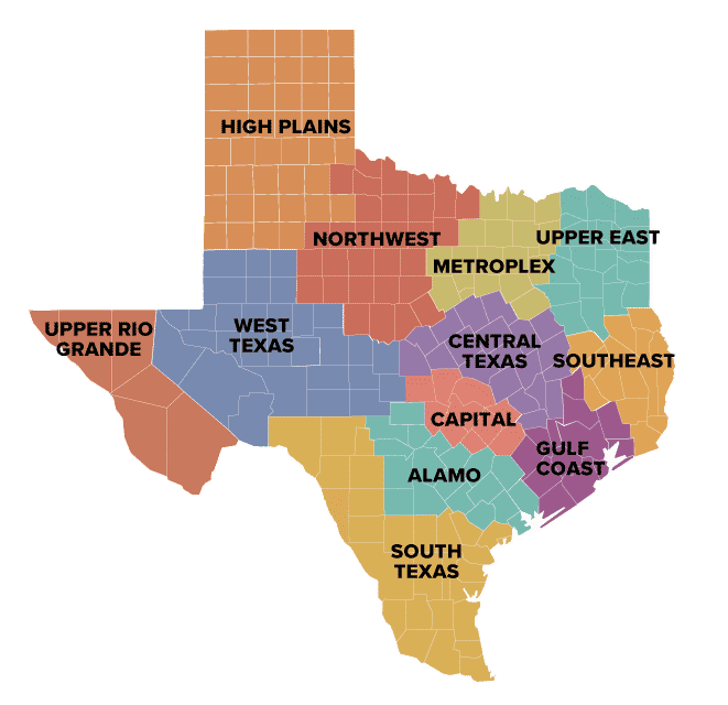
The 2018 Texas Regional Report has been compiled from an analysis of the 12 Comptroller Economic Regions.
Read the Texas Regional Report | View the Statewide Snapshot | Printable Statewide (PDF)
Get an overview of population, income, jobs, wages and education trends of in each of Texas' 12 economic regions.
Alamo
Alamo Region Counties
- Atascosa
- Bandera
- Bexar
- Calhoun
- Comal
- Dewitt
- Frio
- Gillespie
- Goliad
- Gonzales
- Guadalupe
- Jackson
- Karnes
- Kendall
- Kerr
- Lavaca
- Medina
- Victoria
- Wilson
The 19-county Alamo Region covers about 18,000 square miles in south central Texas, stretching from Fredericksburg and Kerrville in the Hill Country to Port Lavaca on the Gulf Coast.
Capital
Capital Region Counties
- Bastrop
- Blanco
- Burnet
- Caldwell
- Fayette
- Hays
- Lee
- Llano
- Travis
- Williamson
The 10-county Capital Region covers about 8,600 square miles in central Texas, stretching from Llano to San Marcos and from La Grange to Georgetown.
Central Texas
Central Texas Region Counties
- Bell
- Bosque
- Brazos
- Burleson
- Coryell
- Falls
- Freestone
- Grimes
- Hamilton
- Hill
- Lampasas
- Leon
- Limestone
- Madison
- Mclennan
- Milam
- Mills
- Robertson
- San Saba
- Washington
The 20-county Central Texas Region covers about 17,400 square miles in the heart of Texas, stretching from Hillsboro on the north to Interstate 45 on the east to East Yegua Creek on the south to the conjunction of the San Saba and Colorado rivers.
Gulf Coast
Gulf Coast Region Counties
- Austin
- Brazoria
- Chambers
- Colorado
- Fort Bend
- Galveston
- Harris
- Liberty
- Matagorda
- Montgomery
- Walker
- Waller
- Wharton
The 13-county Gulf Coast Region covers about 13,900 square miles in eastern coastal Texas, stretching from Huntsville on the north to Matagorda Bay and Galveston along the Gulf Coast.
High Plains
High Plains Region Counties
- Armstrong
- Bailey
- Briscoe
- Carson
- Castro
- Childress
- Cochran
- Collingsworth
- Crosby
- Dallam
- Deaf Smith
- Dickens
- Donley
- Floyd
- Garza
- Gray
- Hale
- Hall
- Hansford
- Hartley
- Hemphill
- Hockley
- Hutchinson
- King
- Lamb
- Lipscomb
- Lubbock
- Lynn
- Moore
- Motley
- Ochiltree
- Oldham
- Parmer
- Potter
- Randall
- Roberts
- Sherman
- Swisher
- Terry
- Wheeler
- Yoakum
The 41-county High Plains Region covers about 39,500 square miles in north Texas, stretching from the Oklahoma state line on the east and north and the New Mexico state line on the west to the Lubbock metro area on the south.
Metroplex
Metroplex Region Counties
- Collin
- Cooke
- Dallas
- Denton
- Ellis
- Erath
- Fannin
- Grayson
- Hood
- Hunt
- Johnson
- Kaufman
- Navarro
- Palo Pinto
- Parker
- Rockwall
- Somervell
- Tarrant
- Wise
The 19-county Metroplex Region covers about 15,600 square miles in northern Texas, stretching from Oklahoma south to the Brazos River and from the Cedar Creek Reservoir on the east to Possum Kingdom Lake on the west.
Northwest
Northwest Region Counties
- Archer
- Baylor
- Brown
- Callahan
- Clay
- Coleman
- Comanche
- Cottle
- Eastland
- Fisher
- Foard
- Hardeman
- Haskell
- Jack
- Jones
- Kent
- Knox
- Mitchell
- Montague
- Nolan
- Runnels
- Scurry
- Shackelford
- Stephens
- Stonewall
- Taylor
- Throckmorton
- Wichita
- Wilbarger
- Young
The 30-county Northwest Region covers about 27,600 square miles in northern Texas, stretching from Oklahoma on the north to the Colorado River on the south and abutting Big Spring on the west and the Fort Worth metro on the east.
Southeast
Southeast Region Counties
- Angelina
- Hardin
- Houston
- Jasper
- Jefferson
- Nacogdoches
- Newton
- Orange
- Polk
- Sabine
- San Augustine
- San Jacinto
- Shelby
- Trinity
- Tyler
The 15-county Southeast Region covers about 12,800 square miles in easternmost Texas, stretching from the Gulf of Mexico to Nacogdoches along the Louisiana border.
South Texas
South Texas Region Counties
- Aransas
- Bee
- Brooks
- Cameron
- Dimmit
- Duval
- Edwards
- Hidalgo
- Jim Hogg
- Jim Wells
- Kenedy
- Kinney
- Kleberg
- La Salle
- Live Oak
- Maverick
- McMullen
- Nueces
- Real
- Refugio
- San Patricio
- Starr
- Uvalde
- Val Verde
- Webb
- Willacy
- Zapata
- Zavala
The 28-county South Texas Region covers about 37,800 square miles in southernmost Texas, stretching along the Mexican border from Del Rio to Brownsville and up the Gulf coast past Rockport to Aransas Pass and San Antonio Bay.
Upper East
Upper East Region Counties
- Anderson
- Bowie
- Camp
- Cass
- Cherokee
- Delta
- Franklin
- Gregg
- Harrison
- Henderson
- Hopkins
- Lamar
- Marion
- Morris
- Panola
- Rains
- Red River
- Rusk
- Smith
- Titus
- Upshur
- Van Zandt
- Wood
The 23-county Upper East Region encompasses about 16,000 square miles in the northeast corner of Texas, stretching from the Arkansas and Louisiana borders on the east to Cedar Creek Reservoir in the west.
Upper Rio Grande
Upper Rio Grande Region Counties
- Brewster
- Culberson
- El Paso
- Hudspeth
- Jeff Davis
- Presidio
The six-county Upper Rio Grande Region covers about 21,700 square miles in westernmost Texas. It stretches from the extreme western part of the state, where it meets Mexico and New Mexico, along the Rio Grande past Big Bend and up to the New Mexico border around the area of Guadalupe Mountains National Park.
West Texas
West Texas Region Counties
- Andrews
- Borden
- Coke
- Concho
- Crane
- Crockett
- Dawson
- Ector
- Gaines
- Glasscock
- Howard
- Irion
- Kimble
- Loving
- Martin
- Mason
- McCulloch
- Menard
- Midland
- Pecos
- Reagan
- Reeves
- Schleicher
- Sterling
- Sutton
- Terrell
- Tom Green
- Upton
- Ward
- Winkler
The 30-county West Texas Region covers about 39,800 square miles in western Texas, stretching from the cities of Mason and Brady on the east, to the Rio Grande just south of Dryden and north to the city of Seminole.
View the regional economic analysis from 2015 »
For details on Texas revenues and expenditures, read the State of Texas Annual Cash Report
Additional State Research Tools
Use these lookup tools at other state agency websites to continue research of regional economic data.
Questions?
If you have any questions or concerns regarding the material on this page, please contact the Comptroller’s Data Analysis and Transparency Division.